Step 1
Choose the place
28.6° N / 77.2° E
Search or enter coordinates. Check the detected time zone; border locations may need a manual correction.
Plan a low-Sun window first, then check the weather and the actual horizon.
Plan a low-Sun window first, then check the weather and the actual horizon.
28.6° N / 77.2° E
Search or enter coordinates. Check the detected time zone; border locations may need a manual correction.
2026-10-13
Compare nearby dates and select the angle convention. Golden hour is not a fixed sixty-minute interval.
−4° ↔ +6°
Check both endpoints, bearings and unavailable crossings. Share the setup or export existing windows to your calendar.
For portraits, compare morning and evening before selecting a call time. Check the event bearing against the intended camera direction. With the Sun in the west and a west-facing camera, the subject is broadly backlit; reverse the camera direction for front light. Inspect buildings and trees along that bearing.
Arrive before the selected window for setup and keep an open-shade alternative. For interviews or repeated takes, plan the shot order because exposure, color and shadows change during the window. The duration is usable planning context, not a promise that every minute has identical light.
For a landscape or building facade, enter the viewpoint's coordinates rather than relying on the center of a nearby city. Select the intended date and compare the relevant event azimuth with the direction of the landform or facade. A season change can move the Sun to a different part of the horizon.
For architecture, check blue hour as well: sky light and illuminated windows can offer a different balance after direct sun has gone. On a mountain overlook, scout the ridge separately. This tool has no terrain or observer-height field, so a complete astronomical window can still be blocked.
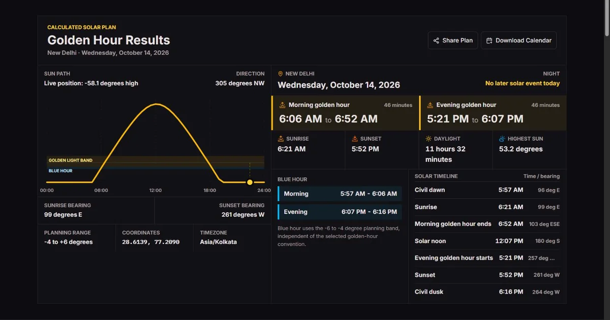
For a team, agree on location, local date, time zone and range before sharing. At the fixed New Delhi example below, the default evening window ends at 18:08, whereas the Sunrise convention ends at 17:53. That distinction matters when one person expects direct sunlight and another plans through twilight.
Export the available golden windows, then add travel and setup time as separate calendar entries. The file is a snapshot, not a reservation or a weather update. For travel or event filming, check access and opening hours independently; the solar schedule cannot verify them.
Search for a place and verify the selected result; similarly named towns and broad city centers are easy to confuse. Exact latitude and longitude are useful for beaches, rural viewpoints and trailheads. North/east are positive and south/west negative. A manual point needs no place lookup, so it remains an alternative when search is unavailable or device location is denied. The latitude and longitude checker can help locate an exact viewpoint before you transfer its coordinates.
The automatically suggested place is approximate. Device location is requested through its control; it is not required to calculate a manual plan. Cancel can stop a pending location attempt. When any location changes, inspect the resulting coordinates and zone before planning: an IP-derived city is not evidence that the viewpoint was found.
Choose a date between 1900 and 2100, use the previous/next date controls to compare nearby days, or return to today in the selected place. Check the IANA zone, such as Asia/Kolkata, and apply a correction when needed. Today refers to that zone, which can be a different date from the computer's location. A zone override changes the civil-day framing and clock display, not Earth's solar motion. Compare collaborators’ local clocks with the world clock while keeping this plan in the shoot location’s zone.
Sunrise is not defined as the solar center reaching zero degrees. The standard apparent-horizon event places the center about 0.833° below the geometric horizon, accounting for the solar radius and average refraction. Civil twilight instead uses the center at −6°. These astronomical definitions give reproducible reference points.
Golden hour has no single official photography boundary. This tool offers −4° to +6°, apparent sunrise to +6°, or −6° to +6°. Blue hour remains −6° to −4° in each case. Changing the convention changes the window, not the Sun’s actual path or a forecast of cloud color. USNO definitions of sunrise and twilight.
A local date can contain 23 or 25 elapsed hours when daylight saving changes. Calculating the local-day boundaries first avoids borrowing the computer’s date or assuming every day lasts exactly 24 hours. The sun-path axis shows local clock times; repeated hours can occur on a fall-back date.
Near the poles, the Sun may never cross one of the chosen angles. A winter day can have sunrise but no +6° crossing; a summer day can have daylight without sunrise or sunset. Missing endpoints are left unavailable and incomplete windows are not exported as fabricated calendar events.
A calculated horizon time remains an estimate. A shallow path makes small changes in refraction or topography much more important. Check cloud, haze, buildings and terrain on location rather than interpreting minute-level display as a guarantee of visible light. NOAA explanation of solar calculation assumptions and limits.
Photography is a flexible default that includes twilight around the apparent horizon event. Sunrise is narrower and focuses on low direct daylight when the horizon is clear. Civil is useful when the transition from twilight belongs in the schedule. The names are conventions: a broad range does not mean direct sun exists throughout it.
For a reproducible example, enter latitude 28.6139, longitude 77.209, date 2026-10-13 and zone Asia/Kolkata. Change only the convention. The +6° boundaries stay fixed, while the outer twilight boundary moves. The table shows rounded local clock times from the engine, not an observed shoot or a weather forecast.
Blue hour stays −6° to −4°. With the default convention it adjoins the golden window; with Civil it overlaps the broader golden label. Neither window marks a physical switch of sky color. Use the event rows to distinguish sunset from the end of a named planning band, and do not subtract a generic hour from sunset to replace the computed start.
| Convention / altitude | Morning | Evening |
|---|---|---|
| Photography: −4° to +6° | 06:06–06:52 | 17:22–18:08 |
| Sunrise: −0.833° to +6° | 06:20–06:52 | 17:22–17:53 |
| Civil: −6° to +6° | 05:56–06:52 | 17:22–18:17 |
| Blue hour: −6° to −4° | 05:56–06:06 | 18:08–18:17 |
Clock times and durations are rounded independently. The same inputs should reproduce the examples; actual visible light depends on the horizon and weather.
Azimuth is clockwise from true north: 0° north, 90° east, 180° south and 270° west. It tells you where to look horizontally. Altitude tells you how high the Sun is above the ideal horizon; a negative altitude means the center is below it. Do not confuse either angle with site elevation in meters, which is not an input here.
The example's sunset bearing is about 261°, slightly south of west rather than due west. Compare the event bearing with the direction the camera faces: Sun behind the camera gives front light, to the side gives side light, and toward the camera gives back light. A compass set to magnetic north may need its own correction before comparison with true-north bearings.
The chart shows the solar path across the selected local day. Its marker follows the current position for today; for another date it marks solar noon rather than simulating the current time on that date. The Earth's axial tilt changes the seasonal path, so a steep horizon crossing is shorter and a shallow one longer. The same angle band need not have the same duration in London, Singapore or Sydney.
Low sunlight travels through more atmosphere, which changes the balance of colors through scattering. It does not guarantee golden skin tones or a red sky: clouds and haze can remove direct light entirely. Direction, obstruction and the atmosphere are separate reasons a geometrically correct time may not produce the image you imagined. For moisture context, use the dew point calculator with local air-temperature and humidity readings; it does not forecast clouds or visibility. NWS explanation of sunlight color and atmospheric scattering.
If another timetable differs, match the coordinates, local date, zone and definition first. Sunrise uses the apparent upper-limb horizon convention, not the center at 0°. A one-hour discrepancy often deserves a zone/DST check before an astronomical investigation. Near a zone border, apply the zone used at the shoot, not a guessed longitude-based offset.
Unavailable means the needed crossing is absent from the selected civil day. It can occur with polar day, polar night or only some missing angle events; it is not the same as zero minutes. Inspect the available event rows and neighboring dates. A low Sun can persist without making a complete start/end pair, and this page does not invent an all-day golden-hour calendar event.
Share includes rounded coordinates, place label, date, zone and convention. Review the label and point before sending a private location. Calendar download includes only complete morning/evening golden windows, not blue hour, travel, reminders or every event row. It uses UTC instants; a recipient's calendar can display a different clock time while representing the same moment. Re-export after changes: an imported file does not stay linked to the calculator.
Solar events are calculated from coordinates for the selected local civil date, with a sea-level unobstructed-horizon assumption. Time-zone rules apply the date’s daylight-saving offset; the detected zone is approximate and can be overridden. Dates from 1900 to 2100 are supported. Azimuth is clockwise from true north.
−4° ↔ +6°; −0.833° ↔ +6°; −6° ↔ +6°; −6° ↔ −4°
No weather forecast, terrain obstruction, observer-height correction or personalized exposure advice is included. Polar and limited-crossing days may have no complete window. Coordinates near time-zone boundaries need checking. Time-zone data and astronomical approximations are planning aids, not guarantees of an observed sunrise.
Search uses GeoNames and OpenStreetMap contributors’ place data. Device coordinates are sent for a place label; manual coordinates need no lookup. Shared links contain coordinates, date and time zone. On a visit without a shared location, the page also requests an approximate location from your IP address automatically.
Testing methodologyInclude the local date, coordinates, selected time zone, convention and event when reporting a mismatch. Compare the same horizon definition and check daylight saving first. Do not share a private place label or exact coordinates publicly unless you intend to.
Corrections policyNo. The duration depends on latitude, date and angle convention. Some polar dates do not have the crossings needed for a complete window.
During polar day the Sun can remain above the rise/set horizon for the whole local day. Daylight does not require a sunrise crossing within that date.
Select the shoot location, check its zone, and use Today. The selected place's civil date is used, not necessarily the date where your computer is. Read both windows in the displayed zone. A shared plan fixes a date; it does not keep following today automatically.
Yes. Search for a place or enter coordinates manually. If search fails, manual coordinates bypass the lookup. Check the suggested zone after applying them. An approximate automatically suggested location is only a starting point, and neither location method establishes that buildings or terrain leave a clear horizon.
Solar noon is tied to the Sun's daily transit, while civil noon belongs to a legal clock zone. Longitude within the zone, the seasonal equation of time and daylight saving can separate them. Use the solar-noon event as a solar reference rather than moving the whole schedule to make it agree with 12:00.
Civil spans −6° to +6°, while blue hour remains −6° to −4°. That twilight portion belongs to both named planning ranges. It is deliberate, not duplicate time in the Sun's path. Choose Photography or Sunrise if your team wants a narrower golden-hour label.
No. They are measured clockwise from true north. A phone or compass can use magnetic north depending on its settings, so compare like references. The bearing also does not say whether a building or ridge blocks that direction; you still need to inspect the viewpoint.
Neither. It contains the complete golden windows available for the chosen setup as fixed events. Blue hour and setup time must be scheduled separately. Weather is not fetched here, and changing the web plan does not alter a file already imported into a calendar.
The band describes solar altitude, not a cloud forecast or an unobstructed view. A mountain, building or cloud layer can hide direct light. In twilight the Sun may already be below the horizon. Use the range, event bearings and local scouting together rather than expecting a uniform lighting effect.
Check the selected IANA zone and date, including daylight saving, then confirm the comparison source uses the same zone. Avoid replacing a named zone with a fixed UTC offset for a future date. If the discrepancy remains, record coordinates, convention and the specific event rather than just a city name.