Find your bearings while travelling
Compare the nearby address with a visible landmark before opening directions. Indoors, allow for a wider uncertainty circle.
Our location finder helps you answer a practical question: where am I, and how confidently can I describe that place? Start with your device, choose a place yourself, or check an approximate area. We keep those three kinds of result distinct.
Use Find my location for a device reading. If permission is unavailable, enter a place or coordinates instead. The approximate-area option is useful for orientation, not finding a street address.
Check the coordinates, nearby address and accuracy together. A marker is a point; an accuracy circle shows the uncertainty supplied by your device. An address lookup can finish after the coordinates appear.
Copy a coordinate pair, open directions, or download a report. Reports hide precise details by default. A shared location link contains the selected coordinates, so check the recipient before sending it.
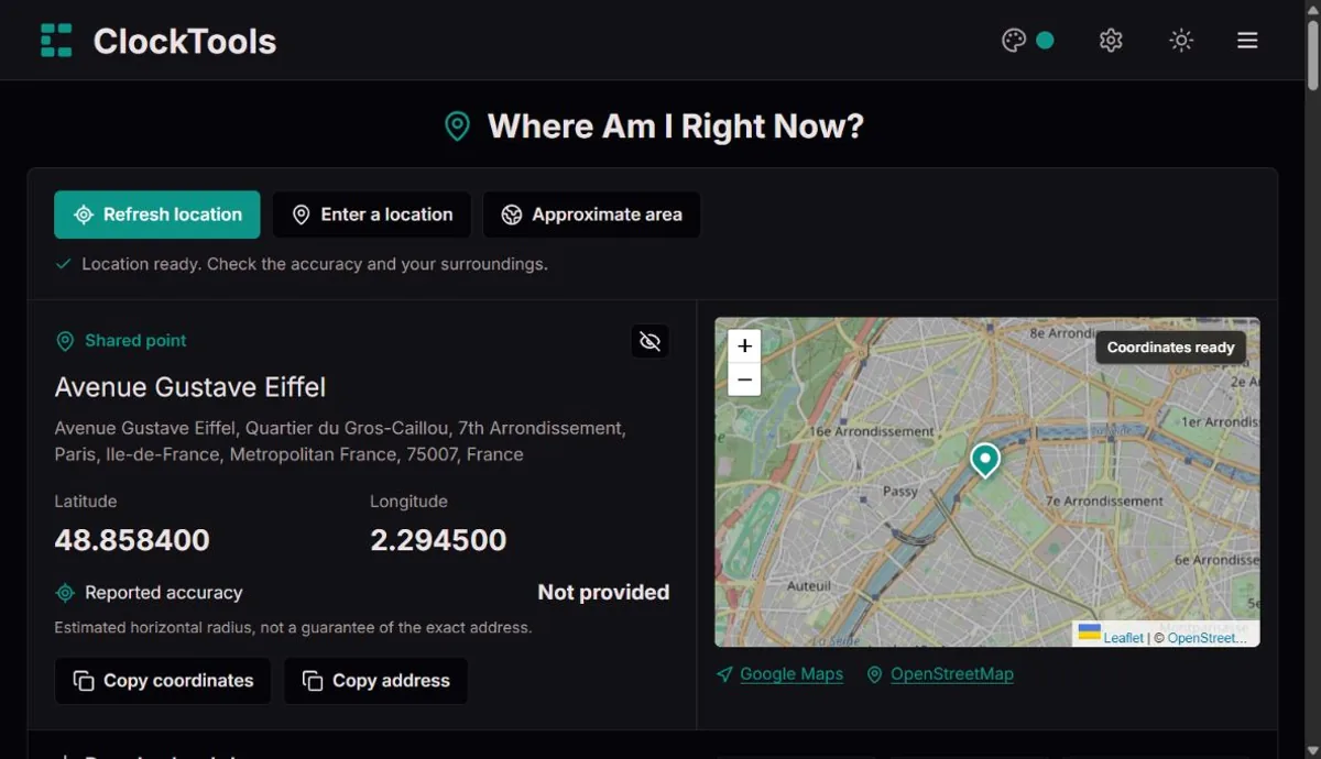
Compare the nearby address with a visible landmark before opening directions. Indoors, allow for a wider uncertainty circle.
Send a selected public entrance or landmark rather than automatically sharing your current position. A map point does not identify the correct floor or doorway.
Record coordinates, units and the reading time in a branded PNG or text report. Include the accuracy estimate when comparing observations.
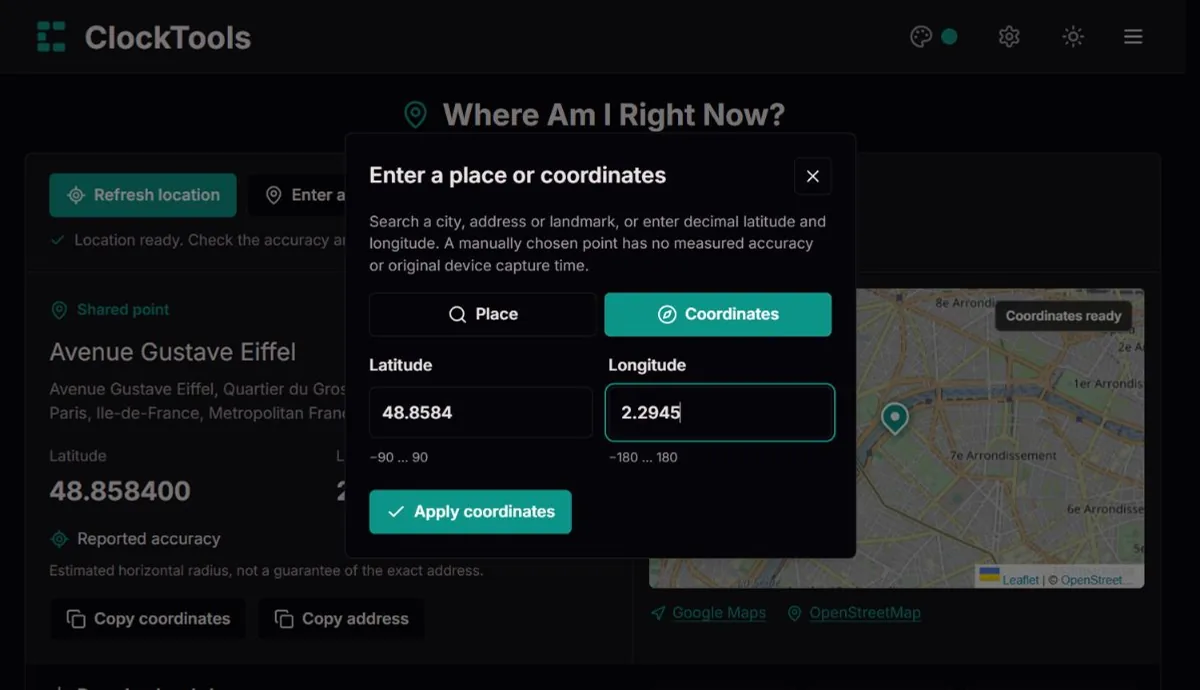
Search for a place or enter its coordinates. This is useful on a desktop, on a managed device, or when you prefer not to grant location permission.
Your device may return a quick estimate first and improve it afterwards. Refresh requests a new reading; this page does not continuously follow your movement.
Search a city, address or landmark, or enter decimal latitude and longitude. A manually chosen point has no measured accuracy or original device capture time.
A connection-based area can differ from your physical position, especially with a VPN or mobile network. It has no GPS accuracy radius and should not be used for precise navigation.
Hide the map, address and coordinates on this screen. Copying coordinates or sharing a point still sends the real values; their controls say so explicitly.
PNG and TXT include the source, time and available readings. Keep the privacy checkbox selected to omit coordinates and address. Sharing a point sends a link, not an ongoing live-location feed.
Choose metres and kilometres per hour, or feet and miles per hour. Altitude, altitude accuracy, heading and speed appear only when supplied; missing values are not filled with guesses.
Satellite navigation connects location to time. A navigation signal describes when it left a satellite and where that satellite was. The receiver uses its travel time to estimate distance; several distances help narrow the possible position.
In a basic GPS solution, signals from at least four satellites allow the receiver to solve for three-dimensional position and its own clock error. Your phone does not need an atomic clock inside it. This relationship between timing and position is one reason a location tool belongs alongside our clocks.
Sources and further reading: NISTA map can draw a tiny marker for a very uncertain estimate. Look at the accuracy value instead of treating the pin as proof of an exact address. The browser standard defines horizontal accuracy as an estimated radius in metres with a 95% confidence level; it is not a guarantee for every reading.
Buildings, reflections, available signals and device settings affect the result. A nearby mapped address describes what is recorded around the point, not necessarily the building, entrance or floor where you are standing.
Sources and further reading: W3CLatitude measures north or south of the equator; longitude measures east or west of the prime meridian. Enter latitude first, from −90 to 90, and longitude second, from −180 to 180. Negative values mean south and west.
Decimal degrees and degrees, minutes and seconds describe the same angle. For example, 48.858400° N is 48°51′30.24″ N. Extra decimal places describe formatting precision, not guaranteed positional accuracy. Our conversion carries rounded seconds into minutes and degrees.
Sources and further reading: W3CA device capture time tells you when a position was obtained, which may be earlier than the moment you opened the result. A cached reading can still be useful, but it should not silently look fresh. We flag older device readings so you can decide whether to refresh.
A shared point has coordinates but no original capture time. We show when you opened it; a manual point shows when you selected it. Neither proves that anyone was physically present there. For urgent navigation, verify your surroundings and use appropriate local assistance.
Sources and further reading: MDNIt is frustrating when you ask where you are and the map answers with somewhere else. Before trying again, check the result type. A device reading, a connection-based area and a point you selected are different answers to different questions. Our location finder labels them so you can choose a useful next step.
| What you notice | What to check | A useful next step |
|---|---|---|
| Another city or region | An approximate area may describe your internet connection rather than your physical position. A VPN or mobile connection can make the two differ. | For your present position, choose Find my location and check the device result. A VPN does not necessarily change a device reading. |
| The pin is nearby, but not where you stand | Read the accuracy radius. A neighbouring building inside a wide circle is not evidence that the tool has identified your doorway. | Compare a visible landmark, improve reception if practical, then request a fresh reading. |
| The coordinates look right, but the address is wrong | The address is a nearby map reference. An entrance, business label or road may be missing or outdated. | Use the coordinates with local signs. Report a mapping error to the map service; report a display problem to us. |
| The result stays at an earlier place | Check the reading time and source. A shared or manually chosen point stays at that point; it is not a tracker. | Refresh a device reading after moving. If the request fails, we keep the previous result rather than pretending it is new. |
Repeated clicks cannot override a blocked permission or create a stronger location signal. When you only need to identify a known place, manual entry is often the quickest way forward.
Start with the task, not with whichever button sounds most precise. Finding your current position is different from checking the area associated with your connection or choosing where to meet someone. This comparison helps you avoid treating all three as GPS measurements.
| Result type | What it represents | Best suited to | What it cannot establish |
|---|---|---|---|
| Device location | The position estimate your device supplies after a location request; it is not necessarily based on GPS alone. | Finding your bearings, checking coordinates and recording an available accuracy estimate. | A verified entrance, floor, property boundary or guaranteed exact position. |
| Approximate IP area | An area associated with the public connection. It can differ from where the device is physically located. | Broad regional orientation and comparing connection information with our What Is My IP tool. | Your street address, GPS accuracy or a reliable route to your current position. |
| Manual or shared point | Coordinates selected by you or supplied in a link. They describe a place, not a device observation. | Public meeting points, planning, known landmarks and computers without location access. | That anyone is at the point, when they were there, or how accurately a device measured it. |
If you need to share a destination, select that destination. If you need to describe a device reading, keep its source, accuracy and time together. Those small distinctions make a location report much more useful.
A better result starts with the device and its surroundings. Our page can request another reading, but it cannot switch on a disabled location service, bypass an administrator's rule or guarantee reception indoors. Try the relevant checklist before repeatedly refreshing.
If the next reading is worse, do not assume that newer always means more accurate. Check the evidence together: source, capture time, accuracy and a landmark you can recognise. Settings names vary with device and software version.
Sources and further reading: Google Chrome · Sources and further reading: Apple
The following examples are invented to explain how to read a result. They are not measurements of your device. The circles are schematic, not maps or scale drawings.
Illustrative example, not a live reading
Imagine a reading near a public square with a 20-metre radius. It may help you recognise the surrounding area, but several entrances can still fit inside that circle.
Before sharing a meeting point, select the actual public entrance and describe a visible landmark.
Illustrative example, not a live reading
A radius of 800 metres covers a much broader area. Zooming the map in makes the pin bigger on screen; it does not make the underlying position more certain.
Use this for broad orientation, not to choose a building. Seek a better device reading or select a known place.
Illustrative example, not a live reading
If you have moved since the capture time, even a small accuracy radius describes an older observation. Opening or downloading the result does not refresh that observation.
Refresh before sharing your present position. A selected landmark does not need a device capture time at all.
The best-looking pin is not automatically the best evidence. Our finder keeps missing measurements missing, and distinguishes a selected place from a measured position, so you can interpret the result honestly.
Long before a phone could put a dot on a map, finding a place meant piecing together clues. Our current-location tool sits at the modern end of that story: people have always needed to connect an observation with a dependable reference. Time became one of the most useful references of all.
Near familiar land, a coastline or landmark can answer a practical question: where am I relative to something I recognise? Far from familiar surroundings, recognition becomes less useful. A position needs a reference that can be communicated to someone who cannot see what you see.
Coordinates provide that shared language. They let an observation become a point another person can look up. Yet a coordinate pair alone still leaves questions about the observation, its age and its uncertainty. Those questions have not disappeared just because the map is now on a screen.
Earth turns through 360 degrees in about 24 hours: a difference of one hour corresponds to 15 degrees of longitude. Comparing local solar time with time at a reference meridian therefore gives an east-west relationship. The arithmetic is simple; maintaining a dependable reference on a moving vessel was the difficult part.
John Harrison's H4 longitude timekeeper was completed in 1759. It is a tangible reminder that navigation was also an engineering challenge in timekeeping. A clock had to remain useful away from the conditions in which it was built and checked, not merely look precise on its dial.
Satellite navigation uses a different relationship between time and distance. Instead of carrying a sea clock to compare local noon, a receiver works with timed signals from known satellite positions. This is why accurate timing belongs in the story of both clocks and location.
The practical lesson is not that every phone result is perfect. The timing reference, reception conditions and the device's ability to interpret signals are separate parts of the problem. A sophisticated system can still give a person an uncertain reading in a difficult environment.
Modern location finding brings a position and a map together in a convenient interface. The map adds streets, names and familiar places; it does not turn an estimate into a verified address. The name next to a pin and the measurement behind that pin answer different questions.
That is the connection we want to preserve in ClockTools. Time helps establish where a reading comes from, while clear labels help you decide what to do with it. Whether you are arranging a meeting or noting a field observation, source, time and uncertainty matter more than an impressive number of decimal places.
Our location finder is not a marine chronometer or a surveying instrument. It carries forward a smaller, useful idea: make the reference clear, then help the person understand the observation.
An empty advanced field does not necessarily mean the location request failed. A device can supply coordinates without supplying every other measurement. Manual and shared points have no sensor readings to begin with, and we do not manufacture values to fill the gaps.
| Reading | How to interpret it | What not to assume |
|---|---|---|
| Altitude | A vertical position supplied by the device, when available. | It is not a verified floor number or the height of a building. |
| Altitude accuracy | The device's uncertainty estimate for the vertical reading. | Horizontal accuracy does not automatically describe vertical accuracy. |
| Direction / heading | An available direction of travel, rather than a reliable compass reading of where the phone is pointing. | A stationary device may have no meaningful heading; a missing value is not north. |
| Speed | An available estimate of movement at the time of the reading. | Blank does not mean zero, and one reading is not a continuous speed log. |
| Reading time | The capture time for a device observation, or the opening/selection time for a shared/manual point. | Downloading a report does not make an old device observation current. |
| Browser time zone | The time-zone setting reported by the browser. | It does not prove which geographic time zone contains the map point. |
Choose units for readability, not as a promise of extra precision. For movement over time, our GPS Speedometer is a better fit; for a known destination, the coordinate checker is often enough. Keep this page for understanding one requested reading or selected point.
We distinguish device readings, selected points, shared links and approximate areas. Device accuracy and capture time are shown only when supplied. Address availability does not determine whether a coordinate reading is usable.
Accuracy varies by device and surroundings. A mapped address is nearby reference information, not verified occupancy or an exact entrance. A connection-based area is not a GPS fix. This tool is not intended for emergency, legal or survey-grade decisions.
Report the page language, browser, result type and what looked wrong. Use a public landmark or rounded sample coordinates instead of your private address. We check formatting, labels and handling separately from the underlying location estimate.
How we interpret your result · Corrections and feedbackDevice location starts only when you ask. Finding an address sends the selected coordinates for a nearby-place lookup; external maps also receive the selected point. No continuous tracking or saved location history is started by this tool.
No. Device location is requested only after you press Find my location or Refresh location. Opening a shared point does not request your GPS position.
Permission may have been refused in the browser, disabled in device settings, or restricted by an organisation. Use the permission-help section, or enter a place manually.
Keep any previous usable reading, check that device location is enabled and try again. Near a window or outdoors, reception may improve. Manual entry is available while you resolve the problem.
Not reliably. The mapped address is nearby information, and the device position is an estimate. This tool does not verify a property, entrance, floor or legal address.
Position acquisition and address lookup are separate. An address service may be slow, unavailable or have no mapped result. You can still use the coordinates.
Yes. A browser may use other available location signals. You can also select a place manually or view an approximate area without a device-location request.
No. Hiding protects the on-screen display. A point-sharing link still contains coordinates; use a redacted report when you do not want to disclose them.
No. We show a requested reading or selected point, not continuous tracking. For emergencies, contact local emergency services and follow their location-sharing instructions.