Weather Calculator Tools
Is Golden Hour Really an Hour?
Golden hour can last far less or far more than 60 minutes. Latitude, season, and the chosen solar-angle band determine the actual window.
By Vigneshwaran Vijayakumar, Developer and Publisher | | Reviewed under the ClockTools editorial policy
Table of contents
No. Golden hour is not reliably 60 minutes long. It is the time when the Sun moves through a chosen low-angle band, so its duration changes with latitude, season, date, and the definition you use. In a like-for-like ClockTools test on September 21, 2026, the default photography band of −4° to +6° lasted 41 minutes in Erode, 1 hour 4 minutes in London, and 1 hour 32 minutes in Reykjavík.
Use the Golden Hour Calculator for the location and date you will actually shoot. A generic “one hour before sunset” rule can be a rough reminder, but it is not a calculation.
How long is golden hour?
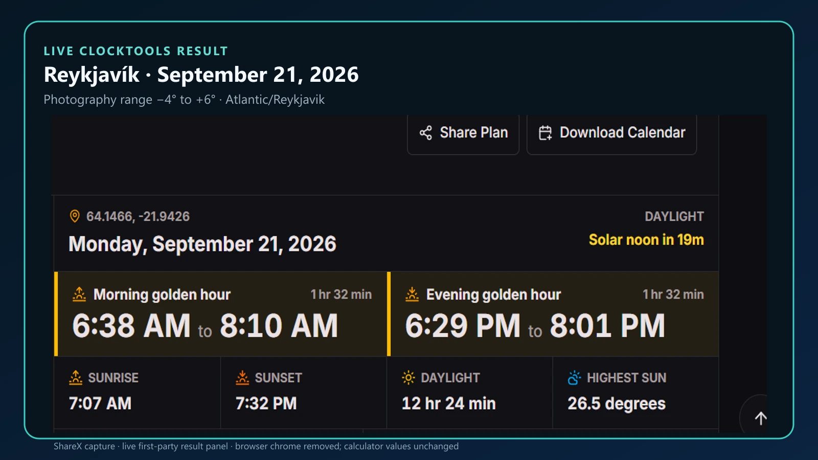
There is no single duration. The clearest way to see that is to keep the date and angle convention fixed, then change only the location. These results were read from the live ClockTools calculator on September 21, 2026, using its Photography range from −4° to +6°.
| Location | Latitude | Morning window | Duration | Sunrise |
|---|---|---|---|---|
| Erode, India | 11.3428° N | 5:55 AM–6:36 AM | 41 min | 6:08 AM |
| London, UK | 51.5074° N | 6:24 AM–7:28 AM | 1 hr 4 min | 6:44 AM |
| Reykjavík, Iceland | 64.1466° N | 6:38 AM–8:10 AM | 1 hr 32 min | 7:07 AM |
The evening windows on that date had the same rounded durations at each location: 41 minutes, 1 hour 4 minutes, and 1 hour 32 minutes. That symmetry is useful for this comparison, but it should not be assumed for every place, date, or rounding method.
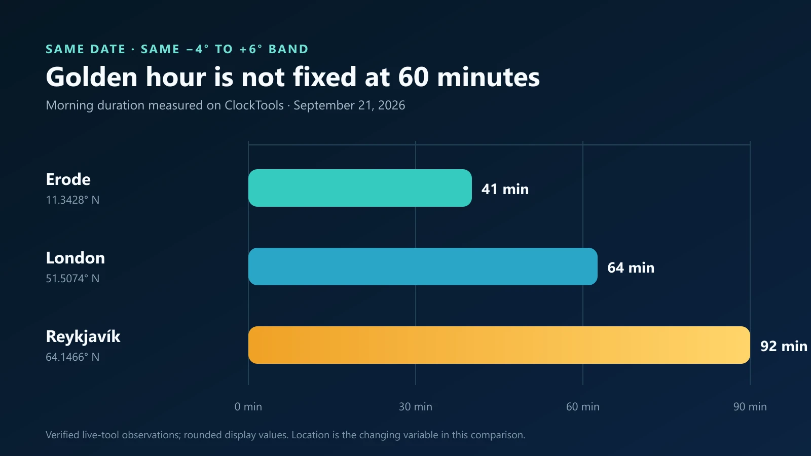
The important point is not that one city always has a specific duration. It is that the same solar-elevation band takes different amounts of clock time to cross. Change the date and the values change again.
Why does latitude change golden hour?
Imagine the Sun’s daily path as a line crossing the horizon. Near the equator, that path usually meets the horizon at a steeper angle. The Sun therefore passes through a narrow low-elevation band relatively quickly. At higher latitudes, the path can meet the horizon more obliquely, so the same angular band takes longer to traverse.
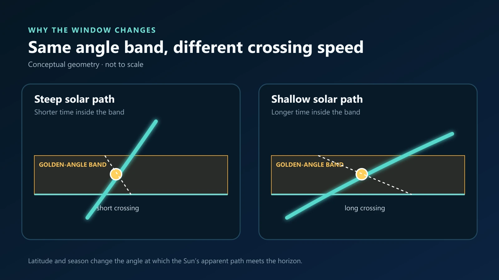
This is a geometry explanation, not a promise that every high-latitude day produces a long, usable golden hour. Near the polar circles, the Sun can skim the horizon, remain above it, remain below it, or fail to cross one of the selected boundaries. In those cases a calculator may show an unusually long window or no complete event.
Why does the season matter?
Earth’s tilted axis changes the apparent solar path during the year. At mid and high latitudes, that seasonal change can substantially alter both daylight length and the angle at which the Sun approaches the horizon. The same viewpoint can therefore have a brief low-light transition in one season and a much slower transition in another.
Season also moves the sunrise and sunset bearings. A façade that receives warm side light in one month may be in shade in another. Check the date as well as the location, and treat the listed azimuth as part of the composition plan rather than an extra statistic.
If you need an exact point for a beach, ridge, or rural viewpoint, use the Latitude and Longitude Checker first and transfer the coordinates to the calculator. Even a correct city time cannot account for a nearby mountain or building that blocks the ideal horizon.
What counts as golden hour?
Photography has no universal authority that fixes one golden-hour boundary. ClockTools therefore makes the convention visible instead of hiding it. Its default Photography range spans −4° to +6° of solar elevation, crossing apparent sunrise or sunset. The tool also offers narrower sunrise-based and broader civil-twilight-based options.
| ClockTools setting | Solar-elevation range | Practical use |
|---|---|---|
| Photography | −4° to +6° | A repeatable warm-light planning window around sunrise or sunset |
| Sunrise | Apparent sunrise or sunset to +6° | Direct low-angle daylight, excluding the pre-sunrise or post-sunset portion |
| Civil | −6° to +6° | A broader setup and transition window that includes civil twilight |
The U.S. Naval Observatory defines civil twilight using a solar center 6° below the horizon and explains the conventional geometry used for rise and set. That is an astronomical boundary, not a guarantee of a particular color palette. Clouds, haze, surface reflection, and white balance can make the light look warm, neutral, or muted inside the same calculated interval.
How should you plan a shoot?
Start with the calculator’s displayed window, then work backward from the photographs you want.
- Set the exact location and local date. Confirm the shown timezone, especially when planning travel or daylight-saving transitions.
- Choose the angle convention. Keep the same convention when comparing dates or locations.
- Read both time and direction. Sunrise, sunset, and boundary bearings tell you which side of a subject can receive direct light.
- Arrive before the window. Use the earlier minutes for access, tripod placement, test frames, and exposure checks.
- Check terrain and weather separately. A ridge can delay direct sunlight; cloud can remove it altogether. The Dew Point Calculator can help assess moisture context, but it does not replace a forecast.
For portraits, a longer high-latitude window can give more time to change poses and backgrounds, although the light still evolves. For architecture, direction can matter more than duration because the useful façade may leave direct light early. For video, plan the shot order: color temperature, shadow length, and exposure can visibly change between takes.
What can the calculation not predict?
ClockTools calculates solar positions for an ideal horizon with the open-source SunCalc model and formats events in the selected location’s IANA timezone. It does not model local hills, buildings, cloud, smoke, or a camera’s dynamic range.
The NOAA Solar Calculator notes that calculated rise and set times use an atmospheric-refraction correction. NOAA’s glossary and the Naval Observatory both caution that actual observations vary with atmospheric conditions, observer height, and the horizon. A mathematically precise crossing is therefore a planning baseline, not a field guarantee.
Use the calculation to answer when the Sun reaches a chosen angle. Use scouting and a current forecast to answer whether that light will reach your subject.
Frequently Asked Questions
Is golden hour exactly one hour long?
No. It is the time required for the Sun to cross a selected low-elevation band, so the duration changes with latitude, season, date, and the boundary convention.
How long can golden hour last?
It can be shorter than an hour near low latitudes and substantially longer at higher latitudes. Near the polar circles, a selected boundary may produce an unusually long window or may not be crossed at all.
Why is golden hour longer at higher latitudes?
The Sun often meets the horizon at a shallower angle, so it takes more clock time to move through the same low-elevation band.
Does golden hour change by season?
Yes. Earth’s axial tilt changes the Sun’s apparent path, daylight length, and sunrise or sunset direction through the year.
What solar angles does ClockTools use for golden hour?
The default Photography setting uses approximately −4° to +6° of solar elevation. The calculator also offers sunrise-based and civil-twilight-based ranges.

About The Author
Vigneshwaran Vijayakumar
Founder, Developer and Publisher of ClockTools | Digital Marketing Manager | India
Vigneshwaran is an engineer with decades of technical experience, including professional work as a Digital Marketing Manager in Dubai. His work connects data analysis, search engine optimization, conversion-rate optimization, content systems, visual production, and applied AI and machine learning. At ClockTools, he turns that multidisciplinary experience into focused browser utilities and practical, source-aware guides.