Geolocation Tools
How Do You Find Coordinates on a Map?
A practical map-coordinate workflow for selecting the right point, copying the right format, and catching sign or order errors.
By Vigneshwaran Vijayakumar, Developer and Publisher | | Reviewed under the ClockTools editorial policy
Table of contents
To find coordinates on a map, zoom to the exact point, drop or select a pin, and copy the latitude-longitude pair shown by the map. On Google Maps desktop, right-click the point and select the coordinates at the top of the menu. On a phone, press and hold to drop a pin, then open the location card. Before sharing the numbers, confirm that latitude comes first, preserve every minus sign, and paste the pair into a second map view to verify the pin.
Which point do you actually mean?
The mechanical step is easy. The judgment comes first. A business label, street address, building center, entrance, parking gate, trailhead, viewing platform, and delivery door can all be different points.
Zoom until the map shows the feature that matters to the recipient. If someone needs to reach a building, select the usable entrance rather than the center of its roof. For a trail, choose the signed trailhead rather than a point deeper inside the park. For an event, use the check-in gate, not the middle of the venue boundary.
This is why coordinates can be better than an address and worse at the same time. They can identify a very specific point, but they do not explain what that point represents. Pair them with a short label such as “north visitor entrance” or “public boat-ramp gate.”
How do you find coordinates on Google Maps?
Google's current Maps help page documents the desktop method and accepted formats.
On a computer
- Open Google Maps and search for the general area.
- Zoom until you can distinguish the exact feature.
- Right-click that point.
- Read the decimal latitude and longitude at the top of the pop-up.
- Select the pair to copy it.
On Android, iPhone, or iPad
- Open the Google Maps app and move to the area.
- Press and hold the exact spot until a dropped pin appears.
- Open or swipe up the pin's information card.
- Find the coordinate pair and copy it, or share the map pin if the recipient only needs navigation.
Mobile interface details can move between app versions, so look for the coordinates in the search field or expanded place card. The durable action is the long press that creates a pin at a point without requiring a named address.
Do not copy numbers from a map URL unless the interface gives you no better option. URLs can contain the map's viewport center, zoom level, a searched place, or an encoded share identifier. The visible coordinate field tied to the selected pin is less ambiguous.
How do you find coordinates from a place name?
A place search is a two-stage operation: geocoding turns the words into one or more candidate points, then you decide which point matches your intent.
Enter enough context to avoid duplicates. “Springfield” is ambiguous; “Springfield, Illinois, USA” is clearer. A street name may need a city and postcode. A landmark may have several mapped objects, including a building outline, entrance, transit stop, and nearby road.
The ClockTools latitude and longitude checker shows alternative matches and an interactive marker. Search the place, inspect the returned city, region, country, and map position, then drag or click the marker if the useful point differs from the search result.
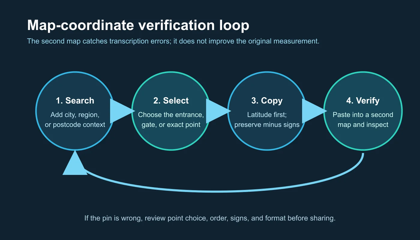
The loop matters because a geocoder's first result is a candidate, not a legal property determination or promise that the pin marks an entrance.
How do you read latitude and longitude correctly?
For ordinary web-map input, read the pair as latitude, longitude.
- Latitude measures north or south of the equator and ranges from
-90to90. - Longitude measures east or west of the Prime Meridian and ranges from
-180to180. - Positive latitude is north; negative latitude is south.
- Positive longitude is east; negative longitude is west.
The pair 48.858370, 2.294481 places latitude first: about 48.86 degrees north and 2.29 degrees east. Swap it to 2.294481, 48.858370 and it remains numerically valid, but it points somewhere entirely different.
Not every software format uses the same axis order. Some GIS systems and data files store coordinates as x, y, which is commonly longitude then latitude for geographic data. Read the receiving system's documentation rather than assuming the order.
Which coordinate format should you copy?
Most everyday map and messaging workflows are simplest with decimal degrees.
| Format | Example | Best fit | Common risk |
|---|---|---|---|
| Decimal degrees (DD) | 48.858370, 2.294481 | Web maps, phones, spreadsheets, code | Lost minus sign or reversed order |
| Degrees, minutes, seconds (DMS) | 48°51'30.13\"N 2°17'40.13\"E | Traditional maps, reports, education | Mixing direction letters with negative signs |
| Degrees and decimal minutes (DMM) | 48° 51.5022' N, 2° 17.6689' E | Selected marine and aviation uses | Minutes copied as decimal degrees |
| Geo URI | geo:48.858370,2.294481 | Compatible location-aware apps | Recipient software may not recognize it |
Google Maps accepts DD, DMS, and DMM. Its help page also specifies latitude first, latitude within -90 to 90, and longitude within -180 to 180.
If you need a moving cursor readout or a visible coordinate grid, Google Earth's coordinate help documents those display options separately. For locations that lack a conventional address, Google's Plus Codes guide describes another shareable location notation.
Use a decimal point rather than a locale decimal comma inside decimal degrees. Writing 41,40338, 2,17403 creates four comma-separated pieces instead of one unambiguous pair. When sharing across locales, keep the coordinates in a code-style line and add a normal-language label separately.
What did a two-map verification show?
I used the public Eiffel Tower quick example in the live ClockTools checker. The tool returned 48.858370, 2.294481, identified the hemispheres as north and east, and displayed DD, DMS, DMM, and Geo URI versions together. It also placed a draggable marker on an OpenStreetMap-based map.
The most useful observation was not the extra formats. The returned wording referred to Avenue Gustave Eiffel, while the marker supplied the spatial context. That difference illustrates why reverse-geocoded text should be treated as the nearest useful mapped description rather than proof that the coordinate belongs to one postal address.
For a verification loop:
- Copy the decimal pair from the first map.
- Paste it into a second map or the ClockTools Coordinates To Place mode.
- Confirm the marker lands on the same feature.
- Compare the direction and order: north/south first, east/west second.
- Zoom in and check the intended entrance, gate, trail junction, or corner.
The second map does not make the source measurement more accurate. It catches transcription, sign, order, and point-selection mistakes.
How precise are copied coordinates?
Decimal places describe smaller intervals, but they do not guarantee that the original point was measured that accurately.
| Decimal places | Approximate latitude interval | Appropriate interpretation |
|---|---|---|
| 2 | About 1.1 km | Area or neighborhood scale |
| 3 | About 110 m | Block or large-site scale |
| 4 | About 11 m | Building or entrance vicinity |
| 5 | About 1.1 m | Fine map point, if source supports it |
| 6 | About 0.11 m | Storage precision, not a survey promise |
Longitude spacing shrinks with latitude, so those distance estimates are not identical everywhere. More importantly, a phone may report an accuracy radius of several metres or much more near tall buildings, indoors, under heavy tree cover, or with weak satellite geometry. Six decimals can preserve a device's output while the real uncertainty remains tens of metres.
For surveying, boundaries, aviation, marine navigation, emergency response, or legal work, use the authoritative coordinate reference system, equipment, and procedure. A consumer map pin is excellent for communication; it is not a cadastral survey.
Which mistakes move the pin?
Use this quick diagnosis when a coordinate lands in the wrong place.
| Symptom | Likely cause | Correction |
|---|---|---|
| Pin lands on another continent | Latitude and longitude reversed | Swap the two values and verify ranges |
| North American point lands east of Greenwich | Missing negative longitude | Restore the west/negative sign |
| App rejects the pair | Decimal commas or extra punctuation | Use latitude, longitude with decimal points |
| Pin is near the place but at the wrong access point | Search result represents a center or label | Zoom in and select the intended entrance |
| DMS result is far away | Minutes or seconds treated as decimals | Convert the format correctly or paste DMS directly |
| Two maps show nearby but different labels | Reverse-geocoding datasets differ | Compare marker positions, not wording alone |
An out-of-range first value is an immediate clue. If a supposed latitude is 122, either the order is reversed or the data use another coordinate system.
How should you share coordinates safely?
Precise coordinates can reveal a home, workplace, current location, routine, or sensitive site. Share only the precision and audience the task requires.
For a public landmark, a coordinate pair and label are usually fine. For a private residence, consider a nearby meeting point or send the pin only to the intended recipient. Remove location metadata from photos before posting when it is not needed. Do not publish coordinates for protected wildlife, private infrastructure, or someone else's live location without authorization.
When clarity matters, send three parts together:
North visitor entrance — 48.858370, 2.294481 — map link
The label explains the point, the pair survives across mapping apps, and the link reduces typing. Before sending, open the link once and confirm it restores the intended marker.
If you already have a coordinate pair, the latitude and longitude checker can reverse-check it and generate a shareable ClockTools link. If you need your device's current position instead of a map-selected point, Where Am I Right Now is the more direct tool and requires an explicit browser location permission.
Frequently Asked Questions
How do I find coordinates on Google Maps on a computer?
Zoom to the exact point, right-click it, and select the latitude-longitude pair shown at the top of the pop-up. Click the pair to copy it, then paste it back into a map search to verify the pin.
How do I find coordinates on Google Maps on a phone?
Press and hold the exact map point to drop a pin, then open the pin's information card and copy the displayed coordinates. The precise location of the numbers can vary by app version.
Which number comes first in map coordinates?
For Google Maps and ordinary ClockTools input, latitude comes first and longitude second. Some GIS files use longitude-latitude order, so always check the receiving system.
Why does a missing minus sign matter?
In decimal degrees, a negative latitude indicates south and a negative longitude indicates west. Removing a minus sign changes the hemisphere and can move the pin thousands of kilometres.
How many decimal places should I share?
Four or five decimal places are enough for many entrance- or map-point uses, but only if the source supports that accuracy. Extra decimals preserve a value; they do not improve the original GPS or map measurement.
Are map coordinates private?
They can be sensitive because a precise point may reveal a home, workplace, current location, or routine. Share only the point, precision, and audience required for the task.

About The Author
Vigneshwaran Vijayakumar
Founder, Developer and Publisher of ClockTools | Digital Marketing Manager | India
Vigneshwaran is an engineer with decades of technical experience, including professional work as a Digital Marketing Manager in Dubai. His work connects data analysis, search engine optimization, conversion-rate optimization, content systems, visual production, and applied AI and machine learning. At ClockTools, he turns that multidisciplinary experience into focused browser utilities and practical, source-aware guides.