Day and Night World Map
What Is the Solar Terminator? Earth’s Moving Day–Night Line
The solar terminator is Earth’s moving day–night boundary. Learn why it curves on maps, tilts with the seasons, and behaves differently near the poles.
By Vigneshwaran Vijayakumar, Developer and Publisher | | Reviewed under the ClockTools editorial policy
Table of contents
The solar terminator is the moving boundary between Earth’s sunlit and unlit hemispheres. In the map’s geometric model, it is the circle of places where the center of the Sun is exactly on the horizon. It looks curved on a flat world map because a circle on a globe is being unfolded onto a rectangle. Earth’s rotation carries the boundary around the planet each day, while Earth’s axial tilt changes its orientation through the seasons.
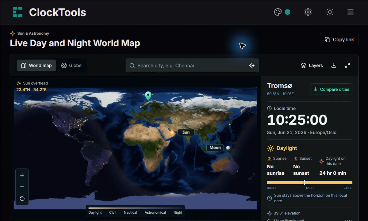
Open the ClockTools Day and Night World Map to freeze that geometry at any instant, switch between the flat map and globe, and compare an equinox with a solstice. The Sun marker shows the subsolar point—the place where the Sun is overhead—so the terminator is always one-quarter of the way around Earth from that marker.
The boundary is a circle, not a painted line
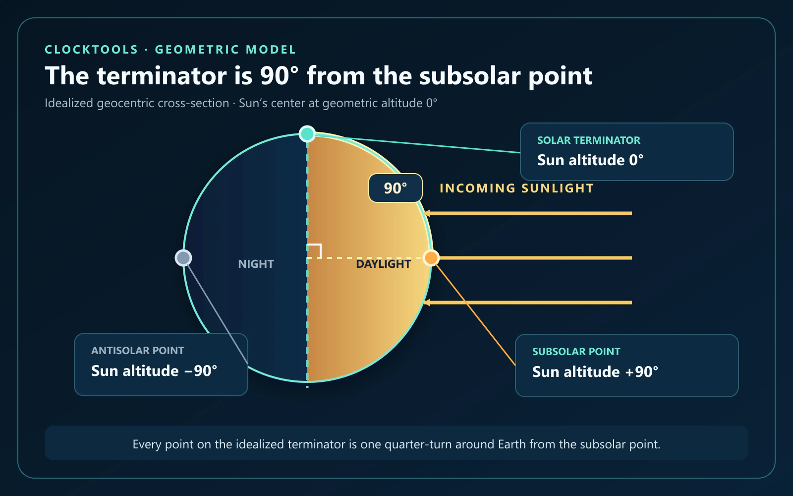
Imagine sunlight arriving from one direction and Earth as a sphere. A plane through Earth’s center, perpendicular to that direction, divides the sphere into a sun-facing half and a night-facing half. Where that plane cuts the surface is the geometric terminator. In the geocentric model used for the map, that cut is a great circle.
Three reference positions make the geometry easier to read:
| Position | Sun’s geometric altitude | Meaning |
|---|---|---|
| Subsolar point | +90° | The Sun is at the zenith, directly overhead |
| Solar terminator | 0° | The Sun’s center is on the geometric horizon |
| Antisolar point | −90° | The Sun is directly below the observer |
Every point on the terminator is about 90° of angular distance from the subsolar point. That is why the Sun marker is more than decoration: it tells you which half of the planet faces the Sun and gives the boundary a precise geometric reference.
The NOAA Science On a Sphere terminator dataset uses the same day–night boundary terminology and shows how its orientation changes across a year. The visible transition is softer than a mathematical line because Earth has an atmosphere; scattering and refraction create twilight around the boundary.
A flat map bends a round-world circle
On the ClockTools globe, the terminator wraps around Earth as a circle. On the rectangular latitude–longitude map, the same boundary is projected onto a flat surface. Most great circles become curves in that representation, just as long-distance flight paths can bend on a flat map even when the route is locally straight.
The map seam matters too. A continuous circle can leave one side of the rectangle and continue on the other. If the boundary appears as two separated curves near the left and right edges, it has not broken; the map has cut the globe at a longitude seam.
At an equinox, the subsolar point is on the equator and the geometric terminator passes through both poles. In a north-up latitude–longitude view, the boundary then appears close to a north–south line. At other times of year, the subsolar point is north or south of the equator, so the projected circle bows and crosses the map edges differently.
Two motions change what you see
The boundary changes on two different timescales. Mixing them together makes the animation harder to interpret.
- Daily rotation changes longitude. As Earth turns, the subsolar longitude and the day–night boundary move around the surface. Advance the ClockTools slider by an hour and the whole pattern shifts across longitudes.
- The annual orbit changes solar declination. Because Earth’s axis is tilted, the subsolar latitude moves north and south during the year. That changes the terminator’s orientation and the amount of each latitude circle inside the sunlit hemisphere.
Rotation explains why a place crosses from night to day and back again. Axial tilt explains why the crossing time and total daylight change with season. The boundary is therefore not a weather front or a fixed longitude; it is the surface expression of Earth’s changing orientation to the Sun.
The seasonal tilt is written into the curve
The equinox and solstice presets isolate the annual change. A controlled 2026 ClockTools calculation produced these reference frames:
| Preset instant (UTC) | Subsolar latitude | Subsolar longitude | Tromsø daylight on its local date | What the map reveals |
|---|---|---|---|---|
| March equinox, March 20 at 14:45:36 | 0.000° | 39.549° W | 12 hr 18 min | The terminator passes through both poles |
| June solstice, June 21 at 08:25:00 | 23.438° N | 54.194° E | 24 hr | The Arctic side remains inside the daylight hemisphere |
| December solstice, December 21 at 20:50:22 | 23.438° S | 133.031° W | 0 hr | The Arctic side remains inside the night hemisphere |
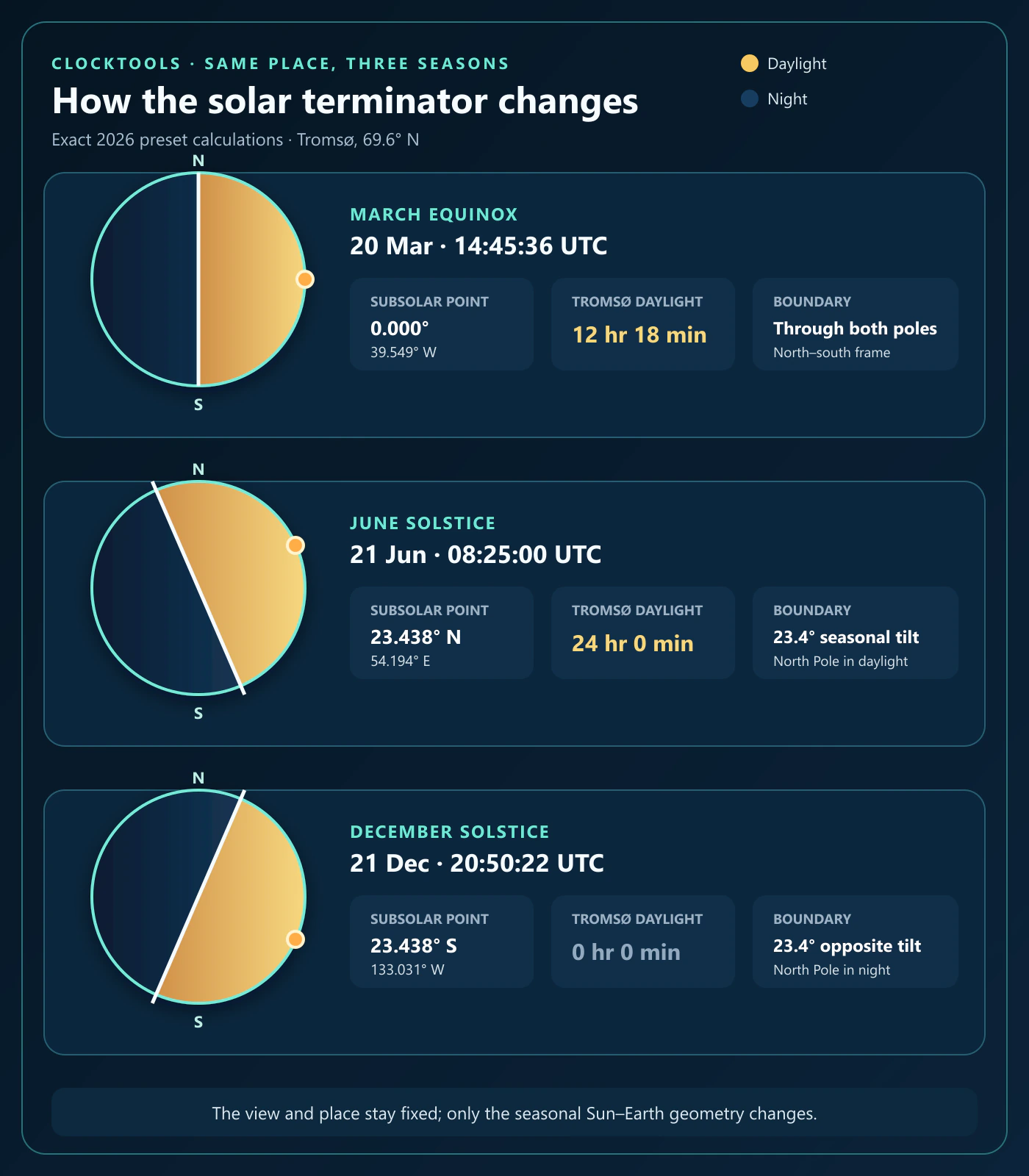
The change is not caused by Earth being meaningfully closer to or farther from the Sun in these frames. It follows the orientation of the tilted axis. NASA’s view of equinoxes and solstices from space shows the terminator running north–south at the equinoxes and leaning as one hemisphere receives more daily sunlight near a solstice.
The table also shows why “equinox” should not be read as a promise of exactly 12 hours between apparent sunrise and sunset. The geometric terminator uses the Sun’s center at 0° altitude. Conventional sunrise and sunset use the Sun’s upper edge and include an average refraction allowance, so the reported daylight interval can be a little longer than 12 hours.
Near the poles, axial tilt can change a whole day
At low latitudes, a location normally crosses the terminator every calendar day. Near a polar circle, the seasonal tilt can place an entire latitude inside daylight or darkness for a full rotation. The boundary then loops around the pole without crossing that location.
Tromsø makes the effect concrete. In the controlled frames above, the March equinox produced both a sunrise and sunset and about 12 hours 18 minutes of daylight. At the June solstice, the tool reported that the Sun stayed above the horizon for the entire local date. At the December solstice, it reported no daylight interval and no sunrise or sunset for that date.
A missing event is therefore not automatically an error. Read it together with the selected latitude, date, daylight total, and the tool’s polar-status message. During polar night there can still be civil, nautical, or astronomical twilight even when the Sun never rises.
A four-frame investigation in ClockTools
Use four deliberate views instead of letting the animation run without a question.
- Freeze the March equinox. Choose Tromsø, select the March equinox preset, and note that the Sun marker is on the equator while the terminator reaches both poles.
- Change only the view. Switch from World map to Globe. The boundary that looked curved or split at the map seam becomes a circle wrapped around the sphere.
- Change only the season. Return to the flat map and select the June solstice. Compare the Sun marker’s latitude, the boundary orientation, and Tromsø’s daylight total.
- Test the opposite extreme. Select the December solstice. The terminator leans the other way and Tromsø changes from continuous daylight to polar night.
Keep Twilight shading on when you want to see the gradual civil, nautical, and astronomical bands. Turn it off briefly when you want the geometric day–night division to stand out. The date field supports UTC instants from 1900 through 2100, and the season presets use the chosen UTC year.
This protocol separates one variable at a time: first projection, then season. It is more informative than comparing two unrelated screenshots with different dates, places, and views.
Limits of the calculated shading
ClockTools calculates the Sun’s position for the displayed instant and applies that geometry to a static Earth basemap. It is not a live satellite camera, weather layer, cloud map, or record of current city-light outages. The boundary shows astronomical illumination, not what a particular street or mountain valley looks like.
The geometric edge also is not an exact apparent-sunrise line. The U.S. Naval Observatory’s rise and set definitions place conventional sunrise or sunset when the Sun’s upper edge appears at a level horizon under average atmospheric conditions; computationally, the Sun’s center is about 0.833° below the geometric horizon. Terrain, observer height, clouds, and changing refraction can shift what someone actually sees, especially where the Sun meets the horizon at a shallow angle.
Use the terminator to understand which side of Earth faces the Sun, how that geometry moves, and why seasons change daylight by latitude. For a photo session or other location-specific plan, follow with the Golden Hour Calculator and a current weather forecast rather than treating the world-map edge as a minute-perfect field observation.
Frequently Asked Questions
Is the solar terminator always a straight line?
No. In the map’s geocentric geometry, the terminator is a great circle on Earth. It can look nearly straight in a north-up flat map at an equinox, but most flat-map views bend or split that circle because a globe is being projected onto a rectangle.
Is the solar terminator the same as the sunrise and sunset line?
Not exactly. The geometric terminator uses the Sun’s center at 0 degrees altitude. Conventional sunrise and sunset use the Sun’s upper edge and an average atmospheric-refraction allowance, so the apparent event can occur while the Sun’s center is below the geometric horizon.
Why does the solar terminator tilt during the year?
Earth’s axis is tilted relative to its orbit. That makes the subsolar latitude move north and south between the solstices, changing the terminator’s orientation and the daylight share received at each latitude.
Does the solar terminator move?
Yes. Earth’s daily rotation carries the boundary around longitudes, while the planet’s annual orbit and axial tilt gradually change the boundary’s seasonal orientation.
Does the solar terminator pass through both poles at an equinox?
The geometric terminator passes through both poles at the exact equinox, when the subsolar latitude is on the equator. Apparent daylight is still not guaranteed to be exactly 12 hours because sunrise and sunset use different horizon conventions and include atmospheric refraction.
Can the Sun stay above or below the horizon all day?
Yes. Near the polar circles, the seasonally tilted terminator can loop around a location without crossing it during one rotation. The result can be a full local date of daylight or a full local date without sunrise.
How wide is the solar terminator?
The ideal geometric boundary has no width, but Earth’s atmosphere makes the observed transition gradual. Civil, nautical, and astronomical twilight describe progressively darker bands on the night side rather than one universal physical width on the ground.

About The Author
Vigneshwaran Vijayakumar
Founder, Developer and Publisher of ClockTools | Digital Marketing Manager | India
Vigneshwaran is an engineer with decades of technical experience, including professional work as a Digital Marketing Manager in Dubai. His work connects data analysis, search engine optimization, conversion-rate optimization, content systems, visual production, and applied AI and machine learning. At ClockTools, he turns that multidisciplinary experience into focused browser utilities and practical, source-aware guides.